1st North-South N 00°05'03" W 4529.100
2nd North-South N 01°09'48" W 4335.400
1st East-West N 89°34'32" W 5821.300
2nd East-West S 89°03'47" W 6971.200
Northing Easting
New Point 248287.938 471213.134
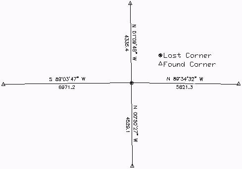
This command is used to
restore a lost corner from new measurements between four known
corners with two measurements each on intersecting meridianal and
latitudinal lines. The program prompts for the four known corner
points to establish the retracement. Plus the program prompts for
the four sets of record bearings and distances from the known
points to the lost corner. The report then shows the calculated
point along with the input data.
Double Proportion
Retrace Point    Northing      Easting

1st North-South  243758.936    471259.132

2nd North-South  252622.467    471144.220

1st East-West    248221.216    477033.581

2nd East-West    248208.591    464242.295
Record           Bearing       Distance

1st North-South  N 00°05'03" W 4529.100

2nd North-South  N 01°09'48" W 4335.400

1st East-West    N 89°34'32" W 5821.300

2nd East-West    S 89°03'47" W 6971.200


                 Northing      Easting

New Point        248287.938    471213.134
Pulldown Menu Location: COGO > Geodetic
Prerequisite: Grid projection under Drawing Setup
Keyboard Command: geodprop