This command creates a grid or triangulation surface file (GRD
or TIN) using the National Elevation Dataset (NED) from the USGS.
Before running this command, the grid coordinate system must be
setup in Settings > Drawing Setup. The program first prompts to
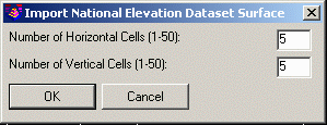
pick a window in the drawing for the surface area. Then there is a
dialog to set the number of sample points. Currently the NED
service is slow. So the number of samples is limited to 50 in X and
Y directions. Also the NED data has limited grid resolution and
does not interpolate. So if your sample spacing is smaller than the
NED resolution, then samples within the same NED grid cell will
have the same elevation.
Pick first
corner of bounding box: Identify one corner of a drawing window for the surface
area
Pick second corner of bounding box: Identify the
opposite corner
Options dialog
Surface File To
Write
Pulldown Menu Location: Civil > Surface >
Import/Export Surface, Survey > Surface > Import/Export
Surface, Construction > Import/Export
Keyboard Command: getneddata
Prerequisite:Coordinate projection system, Internet
connection