This command draws a 3D polyline on the PERIMETER layer. This is
one way to generate the polyline that is required by the
Calculate Stockpile Volume and Calculate Pond/Pit
Volume routines. In these routines, this polyline is used as
the inclusion perimeter for volumes. If you are using Carlson
points to define the polyline, make sure they are present in the
drawing at their real Z elevation, and then set your Object Snap to
Insert prior to running this routine. Alternately, you can use
point numbers from the current coordinate (.CRD) file. A
third option is to obtain the elevations of picked points from a
specified surface model. You have a further option to be prompted
for each elevation, thus overriding the values found from the
included points.
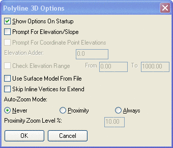
If set to display, the 3D Poly options dialog will appear, and
then you will be prompted for points to use to draw the 3DPoly
Perimeter. Standard Carlson point number input or screen picks
using selection methods are valid.
Dialog Options
Pick point or point number: pick a point or type a
point number
Arc/Close/Undo/Pick point or point number: 15 This is
a point number from the current coordinate (.CRD)
file.
Note that if the response to Use Surface model from file is
Yes, the elevation used is
not the point elevation from the coordinate file (.CRD), but the
elevation interpolated from the surface.
Arc/Close/Undo/Pick point or point number: press
Enter
Draw another 3D polyline [Yes/<No>]? press Enter
Pressing Enter ends the command.
Pulldown Menu Location: Surface >>
Stockpile/Pond/Pit Volumes
Keyboard Command: 3dperim
Prerequisite: None