2D to 3D Polyline by Text With Leader
This command will assign elevations from the labels to the
polylines by following the label leaders to their corresponding
vertices on the polyline.
The command will prompt you
for samples of the elevation labels, the leaders, and the polylines
to convert. The program uses these samples to know the layer names
for the labels and linework to process. Then select all the labels
and leaders for the polylines you want to convert. Since you
pre-specified the layers involved, you may safely window everything
or type the keyword
ALL
and only those layers specified will be examined. You will then be
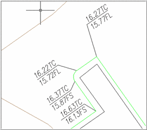
prompted to enter an elevation to add to label values. Often,
elevations are abbreviated to save time and space. For example, if
every elevation in the drawing is in the 800s instead of labeling
every elevation 817.85, 817.40, 817.30 sometimes, like in the above
example, they are listed as 17.85, 17.40, 17.30 This option
allows you to add a given amount, such as 800, to every label
elevation to produce the correct elevation in the drawing.
The program searches
for all leaders and gathers their associated text. If the program
finds different labels in the elevation text, then this dialog box
allows you to select the text you want to use to create the 3D
polylines. In this example you might want to use elevations
followed by TC. This dialog box allows you to select that text and
exclude the other text which is not to be used in the elevations of
the polyline, such as FS.
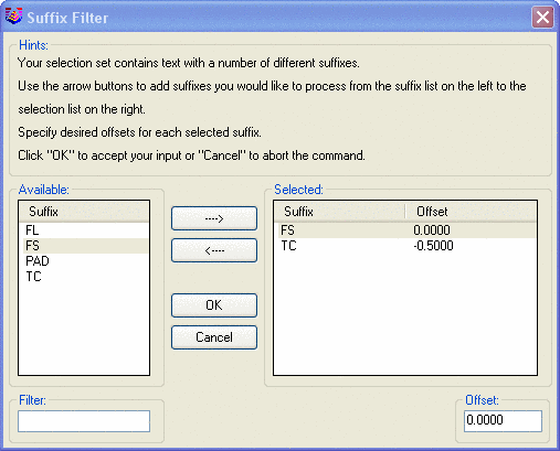
If you are creating 3D polylines from
multiple elevation labels, then this dialog box will allow to
offset certain labels by a given amount. In the above example you
can offset an elevation labeled TC by -0.50 so that it matches
vertices set by FS labeled elevations. Note: you must press Enter after setting the offset amount
to assign it to the selected prefix in the list above.
Prompts
Options/Select sample of elevation text:
pick a text label (Press
O to set tolerance
options).
Select sample of an annotation
leader: pick an annotation
leader
Select sample of a polyline to
convert: pick a
polyline
Select polylines to convert,
leaders and elevation labels to process.
Select objects:
select the desired
entities This will filter by only those layers identified in
above steps.
Joining adjacent polylines...
Reading the selection set ...
Enter elevation to add to label values
<0.00>: 800
Pre-processing entity #19 of
19
Filtering text
entities
Conflict detected: pick polyline
corresponding to current leader
Press N for next selection, A for all objects, or Enter to accept
current object only: press
Enter
Processing leader
#6
Remaking polyline
#1
Pulldown Menu Location: 3D Data >> 2D to 3D
Polyline
Keyboard Command: elevfl
Prerequisite: 2D polyline, elevation labels, and
leaders