|
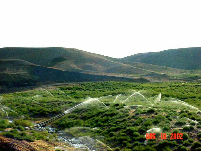
| Figure 2. Steep slope reclamation
using the fluvial geomorphic approach shown during the second growing season |
This fluvial geomorphic landscape computer-design software (GeoFluv™) uses an algorithm based on fluvial geomorphic principles. The essence of this approach is to identify the type of drainage network, i.e., stream channels and valleys, which would tend to form over a long time given the site’s earth materials, relief, and climate to achieve a stable landform, and to design and build that landform. The resulting slopes and stream channels are stable because they are in balance with these conditions (Rosgen, 1996). They are a reclamation alternative to uniform slopes with terraces and down-drains. Rather than fight the natural forces that shape the land, the algorithm helps the user create a landscape that harmonizes with these forces.
The channel and swales in the foreground, and the steep slope ridges, valleys, and channels in the center of Figure 2., are examples of portions of a 115-acre coal mine reclamation project completed using this innovation fluvial geomorphic approach.
|
|
| Figure 2. Steep slope reclamation
using the fluvial geomorphic approach shown during the second growing season |
Natural Stability
Over the last thirty-some years hydrologists have observed and
measured stable natural streams and determined mathematical
relationships that describe these stable stream types.
Essential among these determinations is that channel
morphology is directly related to a relatively small, but
frequently recurring annual flood event. The natural channel is
shaped to keep its sediment load and stream flow in balance during
these low-flow events, as well as during extreme events.
The GeoFluv™ fluvial geomorphic approach to land
reclamation relates the upland landforms to the stream channel
form. Both can be formed similarly by flowing water.
Reclamation landscapes created using fluvial geomorphic principles
provide stability against erosion with runoff waters capable of
meeting water quality criteria, and support a diverse vegetative
community. These landscapes offer the benefits of lower initial
cost, no long-term maintenance costs, and they promote bond release
(Bugosh, 2002, 2003).
Promotes Bond
Release
The GeoFluv™ fluvial geomorphic approach provides a high degree of
confidence that reclamation projects will demonstrate long-term
stability against erosion similar to adjacent undisturbed lands
because the reclamation channels are designed to maintain the
hydrologic balance, as the natural channel does. This means that
the reclaimed land does not have to be regularly disturbed to
repair erosion problems. Additionally, the varied landform provides
niches for different plants, wildlife, and livestock. These
benefits demonstrate to regulatory authorities that the site will
remain stable and productive; that demonstrated stability can
promote bond release.
Benefits of Computerizing the
Fluvial Geomorphic Approach
Previous application of alternative land-shaping practices may have
been limited for several reasons, including the limited extent of
training in fluvial geomorphic principles of the designers, the
complexity of the design calculations to create a thoroughly
integrated landform, and the difficulty of guiding the heavy
equipment operators to build more sophisticated designs. The
Natural Regrade module
addresses all these potential limitations. GeoFluv™ creates a draft
landform based on empirically determined fluvial geomorphic
mathematical relationships. The draft landform is an idealized
solution that uses the input parameters to create a stable
landform. The designer can then modify this idealized draft
landform to conform to special site conditions, such as an
archaeological site, landmark, or other feature, or to create a
more natural appearance.
User Friendly
Existing computer software for earth-moving designs does not
incorporate this innovative approach, is often not “user friendly”,
and does not have the broad applications for landscape designs that
are stable against erosion offered by Natural Regrade. GeoFluv™ makes “user
friendly” computer design software available to a large body of
users that do not have advanced training in fluvial geomorphology,
as well as to those who do have this background. Natural Regrade has been designed to
be as “user friendly” as possible; the program commands are
organized following a left-to-right and top-to-bottom format that
follows the project design work sequence, with minimal input needed
and with guidance provided in the “Help” resource and
documentation.
Minimizes Training
The Natural Regrade module
minimizes the training necessary to immediately use the fluvial
geomorphic approach for reclamation at disturbed sites, or when
evaluating proposed reclamation designs. Users can compress design
time and build reclamation landscapes from disturbed earth to
seeded reclamation. GeoFluv™’s developer has successfully
introduced this reclamation approach to the largest mining company
in the world at truck-and-shovel and dragline operations. The
Natural Regrade module is
designed to quickly make the GeoFluv™ design approach available to
the widest range of users including professional hydrologists,
environmental scientists, and engineers responsible for reclamation
design at disturbed sites, and for regulatory personnel responsible
for evaluating reclamation designs.
Simplifies numerous complex
calculations
An important advantage of the Natural Regrade module’s GeoFluv™
computerized approach is the ease by which the user can create
landscapes that are functional, stable against erosion,
low-maintenance, aesthetically pleasing, and cost-effective. The
GeoFluv™ computer design software offers several options for
developing input parameters from climatic and hydrologic data, and
several options for creating landscape features, e.g., ephemeral,
intermittent and perennial stream channels, complex slopes, ridges
and valleys, and calculating material balances and centroids, and
optimum material movement routes, for the resulting design. The
user can design channels with appropriate characteristics,
including channel patterns, sinuosity, longitudinal profiles, cross
sectional areas, width to depth ratios, etc. and their contiguous
uplands as functional components of a stable topography for tens of
acres of land in minutes. GeoFluv™ allows the user to view
topographic maps and three-dimensional images of the resulting
landscape design. The GeoFluv™ approach replaces lengthy and
tedious manual calculations and allows rapid evaluation of many
landscape design alternatives. This allows the user to select the
optimum landscape design for his needs.
Promotes Bonding
Alternatives
The ability to quickly create and evaluate alternative reclamation
designs provides great utility for both industry and regulatory
personnel working on reclamation bonds. Because designing a
reclamation surface has been such a lengthy and expensive process,
often only a ‘worst case scenario’ design has been created for
setting a reclamation bond. For example, this ‘worst case scenario’
may have been based on the disturbance in year four of a five-year
mine permit. The ability to quickly create design surfaces and
conduct mass balance comparisons makes it practical for the
Natural Regrade module
user to propose bonds for several stages of mine development, i.e.,
incremental bonding, that can reduce bond costs and promote release
of more acres from bond.
Interface with GPS and
Machine-control Software
This software also is ideal for integrating with Global Positioning
System and laser machine control to simplify and speed construction
and reduce costs. Construction of the complex landforms that are
characteristic of stable natural landscapes, and which GeoFluv™
helps the user design, is facilitated by GPS and machine guidance
technologies. The need to survey and stake the designs in the field
is eliminated using these technologies, as is the need for the
construction team to constantly provide guidance to the equipment
operators.