This command compares drillhole data to grid models. Drillhole
values that differ from the grid model by more that the specified
Difference Tolerance are reported. The program can create a
standard format report or the Use Report Formatter option can be
used for custom reports or outputs to different formats like Excel.
The purpose of this command is to check that the grid models match
the source drillhole data.
After selecting the drillholes to process, you choose which
strata process and then which value to process including thickness,
elevation or attribute. Then select the grid model to compare with
and the program generates the report.
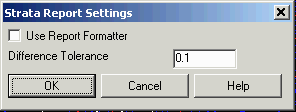
Strata Report Settings dialog
Select drillholes, channel samples and strata polylines.
Select objects: pick the drillholes
Compare Strata to Model
Model: c1_key.grd
Strata: C1_KEY
Attribute: Elevation
Drillhole Name Northing
Easting Elevation
Model Difference
C-3
244124.26 1647252.00 1726.12
1729.23 3.11
C-4
243829.00 1647651.00 1679.12
1679.34 0.22
C-2
244329.00 1647904.00 1826.45
1826.21 -0.24
12 drillholes within tolerance of 0.10
Pulldown Menu Location: Drillhole > Reports
Keyboard Command: chcutsheet
Prerequisite: Grid file and drillholes