Web Feature Service (WFS)
The Web Feature
Service (WFS) command provides an ability to fetch GIS data
from on-line sources as a means to quickly and easily construct
vector map data in and around an area of interest.
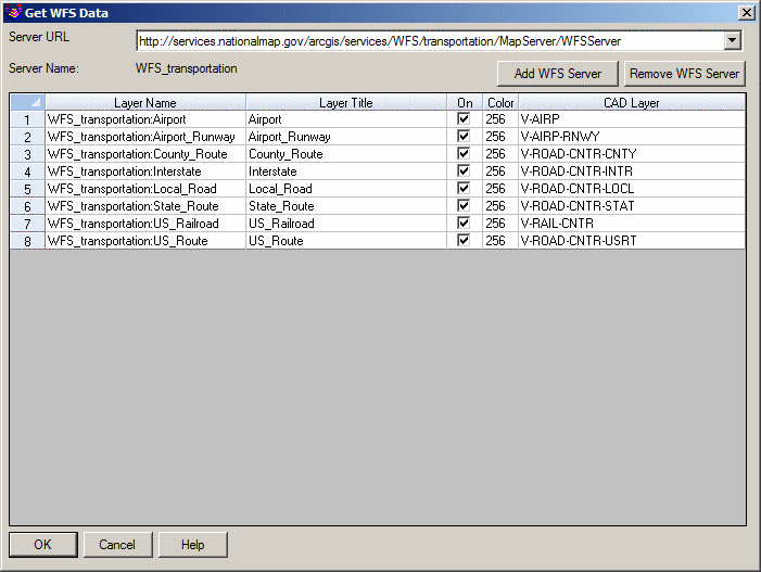
Server URL:
Select the desired Uniform
Resource Locator (URL) from where the geographical data will be
obtained. The default URLs include:
- USGS National Map
- USDA NRCS Soil Data
- FEMA
Server Name: A
read-only label identifying the name of the WFS server.
Add WFS Server: When clicked, the URL of a WFS server may be input that is
subsequently added to the Server URL
drop-list.
Remove WFS Server: Deletes the currently selected WFS Server from the
Server URL drop-list. Prior to the removal
of the WFS Server, a confirmation alert box will be displayed
asking for confirmation. Any data previously placed into a drawing
from the WFS Server will remain in the drawing.
Retrieved Feature(s): As a WFS Server is selected, its list of Features is
returned for further manipulation:
- Layer Name: The geographical "layer" of data in a read-only
format.
- Layer Title: The title of the geographical "layer" of data in a
read-only format.
- On: When
enabled, the content of the Feature is eligible to be imported into
the drawing based on the bounding box
prompts.
- Color: Double-click on the desired Feature Color to expose a
standard "color-picker" dialog box.
- CAD Layer: Key-in the desired Layer name in CAD to house the Feature
data and/or double-click on the desired Feature CAD Layer to expose
a "layer selector" dialog box.
Note:
- Several freely available WFS addresses can be found at the
USGS
National Map Viewer.
- Your local governing agency could/should be consulted to see if
they publish any data via their own WFS.
- Before starting this command, you might find it useful to
position yourself in the desired coordinate location by utilizing
the Place
Google Earth Image command.
- Data limits fetched by bounding box is
based on the following logic:
- Point features - only points within the bounding box are
returned.
- Linear features - only polylines inside or crossing the
bounding box are returned.
- Polygon features - polygons inside or crossing the bounding box
are returned. Additionally, polygons that completely enclose the
bounding box are returned (think of the polygon as a solid object
upon which the bounding box is etched).
Prompts
Pick first corner of bounding
box: Indicate one corner of a
rectangular box that identifies your area of interest.
Pick second corner of bounding box:
Indicate the other corner of a rectangular
box that identifies your area of interest.
See Also:
Pulldown Menu Location(s): GIS Data
Keyboard Command: getwfsdata
Prerequisite: Internet connection, Coordinate System
Projection set through Drawing
Setup