 In this dialog box, the coordinate
file is specified, as well as the Field to Finish file being used.
The name of the SurvCE FCL file is then specified. Picking OK
prompts the user to select the points in the drawing with Esri MSC
data.
In this dialog box, the coordinate
file is specified, as well as the Field to Finish file being used.
The name of the SurvCE FCL file is then specified. Picking OK
prompts the user to select the points in the drawing with Esri MSC
data.This command is used to set up a SurvCE Feature Code Library
(.FCL) with attributes from points in a drawing with Esri MSC
data.
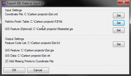
In this dialog box, the coordinate
file is specified, as well as the Field to Finish file being used.
The name of the SurvCE FCL file is then specified. Picking OK
prompts the user to select the points in the drawing with Esri MSC
data.