Coordinate
This feature allows you to draw a table containing information
related to specified points in the coordinate file then place the
table in the drawing by picking the desired location.
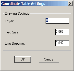
When you pick the Table > Coordinate menu item and a coordinate
file is not already open, you will be asked to open one. Once a
coordinate file is open, then the Coordinate Table Settings dialog
will appear. Using this dialog you can configure the following
settings:
Layer: Specify the layer on
which you want the table drawn.
Text Size: Enter the text
size in inches or centimeters. The text size is the size the
text will appear when printed on a page.
Line Spacing: Enter the
space you want between lines in inches or centimeters. The
line spacing is the height of the spacing when the table is printed
on a page.
Note Northings and Eastings
will be rounded based on the values specified in the Rounding
Options tab of the C&G Options dialog box.
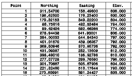
Note The point ID,
northing, and easting will always be part of the coordinate table.
If you want elevations, codes and descriptions shown, make sure
they are set to “On” on the Global Settings tab of the C&G
Options dialog. Click OK to save the settings and continue the
command, this will return the action to the command line. If
you click Cancel the command will be canceled.
Selecting Points for the
coordinate table:
Select the points that will be included in the table using the
familiar C&G prompt.
Choose initial points for base
selection set from coord file. (Enter when done)
[All/Block/Code/Desc/Elev/Pt_group/Limits/Radius/Select]:
A
Prompts
Choose initial points for base
selection set from coord file. (Enter when done)
[All/Block/Code/Desc/Elev/Pt_group/Limits/Radius/Select]:
A
Expand base selection set: Choose
more points from coord file. (Enter when done)
[All/Block/Code/Desc/Elev/Pt_group/Limits/Radius/Select/Include/eXclude/View]:
Building Point Selection Set...
Press Enter 2 more times to end
selection set: <Enter>
When done selecting points just
press <Enter>:The table will be drawn at the
cursor.
Move Coord Table to desired
location: Drag the table to the desired location on the
drawing and press the left mouse button to place the table.
Pulldown Menu Location:
CG-Survey > CGDraw>Tables>Coordinate
Keyboard Command: CRDT,
CG_COORD_TABLE
Prerequiste:
Coordinate file