This command creates a grid or triangulation surface file (GRD
or TIN) using the National Elevation Dataset (NED) from the USGS.
Before running this command, the grid coordinate system must be
setup in Settings > Drawing Setup. The program first prompts to
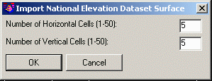
pick a window in the drawing for the surface area. Then there is a
dialog to set the number of sample points. Currently the NED
service is slow. So the number of samples is limited to 50 in X and
Y directions.
Pick first
corner of bounding box: Identify one corner of a drawing window for the surface
area
Pick second corner of bounding box: Identify the
opposite corner
Options dialog
Surface File To
Write
Pulldown Menu Location:
Civil > Surface > Import/Export
Surface, Survey > Surface >
Import/Export Surface, Construction
> Import/Export
Keyboard Command: getneddata
Prerequisite: Coordinate projection system, Internet
connection