To create a profile (.PRO), Profile from 3D Polyline uses X-Y
distances between the points of a 3D polyline for sequential
stations and the Z values at these points for profile elevations.
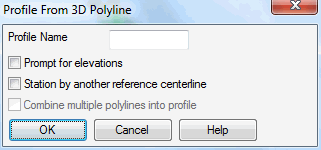
In the options dialog, Profile Name is an optional description for
the profile. The Prompt For Elevations option will prompt for the
elevation at each polyline vertex to use for the profile instead of
using the polyline elevations. The Station By Another Reference
Centerline method locates the station for each polyline vertex
along a reference centerline and uses this reference station
instead of the polyline distance for the profile stationing. The
reference centerline can be defined by another polyline or
centerline file (.CL). When using the reference centerline, the
Combine Multiple Polylines Into Profile option allows you to select
multiple 3D polylines and put the data into a single profile. For
example, you can use these two options to create a profile of curb
elevations with road centerline stationing by selecting multiple 3D
curb polylines and the road centerline as the stationing
reference.
After the options dialog, the program prompts for the .PRO file to create and then the 3D polyline to process.
Profile From 3D Polyline dialog
Profile File to
Write dialog Specify a profile file name to create
Select polyline to profile: pick a 3D polyline
Created 72 data points for profile
C:\sample\abc.pro
The new profile is then stored.
Pulldown Menu Location: Profiles
Keyboard Command: pro3dpl
Prerequisite: A 3D polyline