Import Text/ASCII File
This command converts point data from an ASCII text file into a
Carlson coordinate (.CRD) file. Each line of the text file can
contain any combination of point number, northing, easting,
elevation and description. All point information should be on one
line with the values separated by a comma, space or other
delimiter.
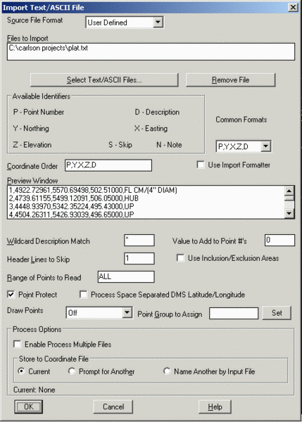 Under the Source File Format
setting you can choose from some specific formats or User-Defined.
For User-Defined, the format of the text file is specified in the
Coordinate Order field where the value identifiers are listed with
the appropriate delimiters. For example:
Under the Source File Format
setting you can choose from some specific formats or User-Defined.
For User-Defined, the format of the text file is specified in the
Coordinate Order field where the value identifiers are listed with
the appropriate delimiters. For example:
For a text file with northing, easting, elevation and comma
delimiters:
5100.0,5150.5,485.1
5127.1,5190.3,487.3
The Coordinate Order would be:
Y,X,Z
For a text file with point number, easting, northing, elevation,
description and space delimiters:
1 5000.0 5000.0 490.3 TRAV
2 5030.4 4930.5 495.5 TRAV
The Coordinate Order would be:
P X Y Z D
Common formats can be selected from the Common Format List. All
the lines in the text file should contain only point data and any
header lines should be removed. To read the text file, pick the
Select Text/ASCII File button and choose the file to read. Then the
selected file is displayed in the Preview Window to help with
filling out the Coordinate Order. When the Coordinate Order is set,
click OK to read the text file.
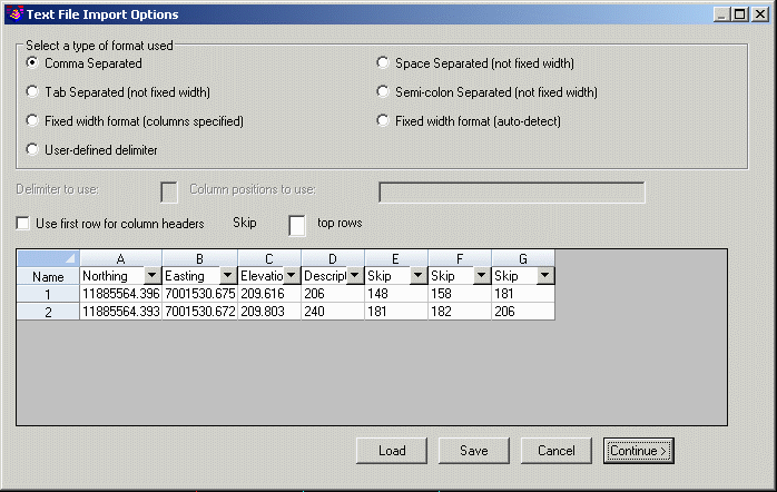
The Use Import Formatter is an alternative way to define the
format of the input file. This method has a heads up interface for
selecting the fields for each column of data. This method also
supports fixed width, user-defined delimiter and semi-colon
delimited files that the Coordinate Order method doesn't
handle.
The Wild Card Descriptions Match allows for only point with
matching descriptions to be imported. The Value to Add to Point
Numbers allows you to renumber the points as they are imported. The
Header Lines to Skip value is the number of lines not to be
processed at the start of the text file. The Point Group To Assign
option will create a point group with the specified name for the
coordinate file containing the point numbers imported with Import
Text/ASCII File. The Use Inclusion/Exclusion Areas option prompts
for selecting closed polylines to control where to import
points.
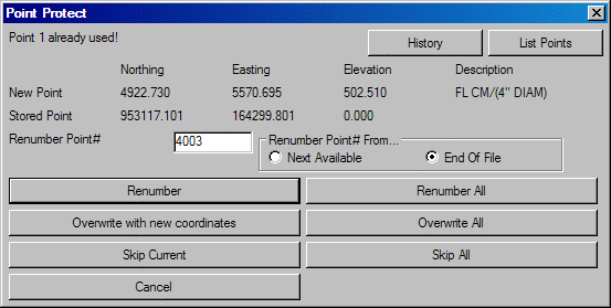
With Point Protect active, the program will check if a point
number already exists in the CRD before importing the point. If a
point conflict is found, you can either assign a new point number
or overwrite the old point.
Multiple files can be imported at once. To do this, toggle on
the Enable Process Multiple Files option. After selecting the
Text/ASCII Files button, you can select multiple files by using the
Shift or Ctrl keys while picking files. You can also run Select
Text/ASCII Files multiple times allowing for selection of files
located in different locations. The files to import are listed in
the top scroll display window. The point data from all the import
files can be stored to the current CRD file or to separate files
for each import file. The separate file option will name the
resulting CRD files with the same name as the import file with a
.CRD file extension. For example, the import file job125.txt would
create job125.crd. The CRD file will be created in the same
location as that of the selected text file to import.
Under Process Options, there are choices for selecting the
coordinate file to store the imported points. The Current option
uses the current coordinate file that is active in the drawing.
This coordinate file name is shown at the bottom of the dialog. The
Prompt For Another option uses the standard file selection dialog
to select the file. The Name Another By Input File uses a
coordinate file name with the same name as the input file except
for a file extension of .CRD.
The Process Space Separated DMS Latitude/Longitude handles a
text file with the degrees, minutes and seconds separated by
spaces. The latitude and longitude values get stored to the
coordinate file in decimal degrees. Here is an example text file
line with the point number (1100), latitude degrees (42), latitude
minutes (6), latitude seconds (3.200), longitude degrees (70),
longitude minutes (2), longitude seconds (2.090) and elevation
(85.245). The Coordinate Order for this example should be set to P
Y X Z.
1100 42 06 03.200 70 40 02.090 85.245
The special formats of Leica .d45/.gsi/.raw files, MicroStation
.TA2 files, TDS .cr5 files, Topobase .ro files, Geodimeter
.obs/.raw/.are files, Laser Atlanta .txt files, Trimble .pos files,
Zeiss .txt files, Traverse PC .trv files, Maptech, Benchmark .dat
files, CAICE/Caltrans .tss files, NLS MMH360 .360 files, EMXS .xng
files, and Cadvantage .cog files can be directly imported by
choosing that File Format at the top of the dialog.
Pulldown Menu Location:
Points
Keyboard Command: readpt
Prerequisite: A text file to read