Create StarNet File
This option converts a raw data file to the Star*Net (.DAT) format.
The raw data file will be preprocessed. During conversion, multiple
distances and angles will be averaged and compared to the maximum
ranges set in the Traverse Options dialog box. To use this option
properly, you must know how Star*Net works. You should be familiar
with all Star*Net codes and commands.
NOTE: This manual is not a
substitute for the Star*Net manual.
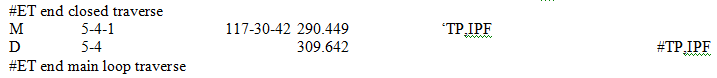
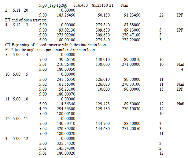
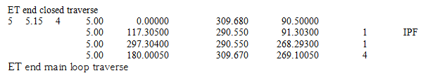
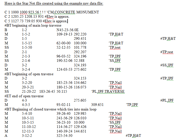
Below is a sample raw data file that contains three
different traverse types. This raw data file can be reduced using
CG-SURVEY or written to a Star*Net file for reduction with
Star*Net, both without any editing.
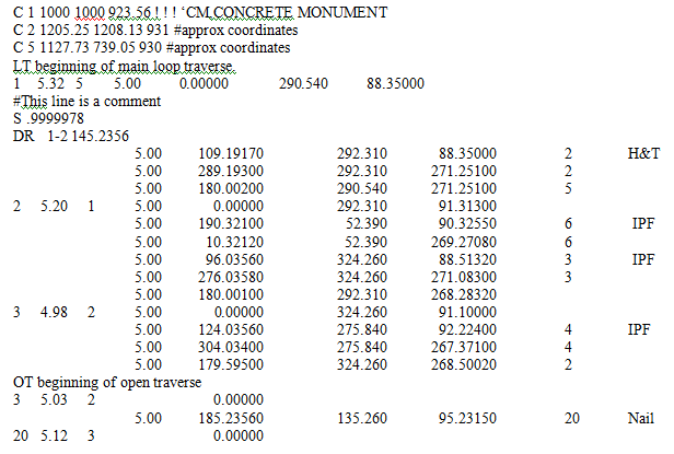
 The coordinate formats (C code)
are the same for Star*Net and CG-SURVEY; no translation is
necessary.
The coordinate formats (C code)
are the same for Star*Net and CG-SURVEY; no translation is
necessary.
If a comment line in the raw data
file uses a valid Star*Net code or command, it will be used
in its original form (as with coordinates); not as a comment. These
codes are #, C, A, D, V, B, M, TB, T, TE, SS (followed by a space)
and all dot commands. (example: .CURVE, .SCALE, etc...)
Multiplication factors are
converted to the .Scale command. The original multiplication
factor set in the Global Options dialog box will be placed at the
beginning of the Star*Net file. Other multiplication factors will
be placed as they occur in the raw data file.
NOTE: You cannot use a
multiplication factor for meter/feet conversion in a 3-D traverse
in Star*Net 3.2.
Reference bearings/azimuths
are converted to the B format.
All traverse points are converted
to the M format and side shots to the SS format. Only points
used once (as a foresight point) will be considered a side shot. If
a point is located from more than one instrument setup, or is used
as an instrument point or backsight point, the point will be
converted to a M format
The LT, ET, OT, FT and CT codes are converted to comments. Point
codes are combined with descriptions.
If Elevations are on, the Star*Net
file must be adjusted as a 3-D traverse. The following could
occur:
If you input slope distances and vertical angles, all distances
will first be reduced to their horizontal/vertical components.
Multiple distances will be averaged and then a slope distance and
vertical angle will be recomputed from the averaged horizontal/
vertical components. This is done so Star*Net can compute
corrections for curvature and refraction and vertical divergence
(can only be done if vertical angles are used in a 3-D traverse.) A
“.Delta Off” command will be placed in the Star*Net file.
If Curvature and Refraction is on in the Options/Global Options
dialog box, a Curve command will be placed in the Star*Net
file.
If you input horizontal and vertical distances, a “.Delta On"
command will be placed in the Star*Net file. No corrections for
curvature and refraction or vertical divergence will be
possible.
If Elevations are off in the Options/Global Options dialog box, the
Star*Net file must be reduced as a 2-D traverse. The following will
occur:
If you input slope distances and vertical angles, all distances
will be reduced to their horizontal/vertical components and the
vertical components will be thrown away.
Multiple distances will be averaged.
No corrections for curvature and refraction or vertical divergence
are allowed in a 2-D traverse with Star*Net version 3.2 or
earlier.
Pulldown Menu Location:
CGTrav
Keyboard Command:STN,
CG_REDUCE_STARNET
Prerequisite: Open CG Raw
file *.CGR