Define Drillhole
This command selects drillhole symbols, defines strata, and
determines how you place drillholes.
Note: The order in
which the Strata are defined in the Strata Definitions list will be
the default order for the strata when you create new drillholes
through Place
Drillhole.
The dialog box below shows the layout of the Drillhole and Strata
Settings.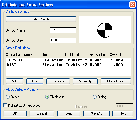 ● Select Symbol:
Select a symbol to represent the drillhole location on the
screen.
● Select Symbol:
Select a symbol to represent the drillhole location on the
screen.
● Symbol
Name: This name corresponds to the symbol
selected.
● Symbol
Size: This field can be edited to adjust the symbols
size displayed on the screen.
● Strata
Definitions: This is not directly editable.
Select the Strata you are interested by highlighting it, then
select the Edit button.
● Add:
This option adds additional strata to the available Strata name
list. See Edit Strata dialog box below.
● Edit:
Similar to Add, this option is available to make changes to the
Strata, including adding a swell factor.
● Strata Name: The name of the
strata.
Density (lbs/ft3): The Strata Density field is the
default density used to calculate strata tons. Density is
strata-specific.
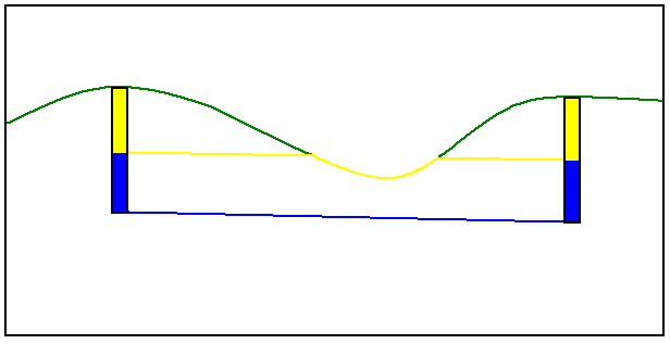
● By Depth: This option will
generate a strata surface by modeling the strata depth values in
the drillholes. This strata surface will follow the existing ground
surface at the model depth.
 ● By
Strata Elevation: This option will generate
a strata model that connects strata irrespective of the upper
surface elevation changes.
● By
Strata Elevation: This option will generate
a strata model that connects strata irrespective of the upper
surface elevation changes.
● Strata Modeling
Method: There are three ways to model strata by Inverse
Distance to the 2nd power, 3rd power, or by linear least
squares.
Inverse Distance (Power 2 and
Power 3) Modeling Method
Inverse distance calculates the strata model by assigning weights
to the drillholes. The strata model calculated by inverse distance
are a weighted average of the drillhole data. Inverse distance will
not carry trends and the calculated surface model will never be
higher than the highest drillhole elevation. Likewise the
calculated strata model will never be lower than the lowest
drillhole elevation. The weights are proportional to the inverse of
the distance between the point to be estimated and a drillhole.
Closer drillholes are weighted more than points farther away. The
inverse distance can be calculated to the second or third power
which are (1/d^2), and (1/d^3) respectively. Inverse Distance -
Power 3 will weigh drillholes less that are further away.
Linear Least Squares Modeling
Method
The linear least squares method finds the least squares best fit
plane across the surface model. The least squares routine weights
each drillhole by inverse distance so that closer points are
weighted more than points farther away. So the best fit plane
varies at different points on the surface. The linear least squares
method extrapolates trends very well. Least squares will trend and
allows for data points that are new highs and lows, that don’t
appear in the original drillhole data.
● Remove: This will remove a strata
name from the available strata.
● Move
Up: This option will move the selected strata name up
one place in the strata name list.
● Move
Down: This option will move the selected strata name
down one place in the strata name list.
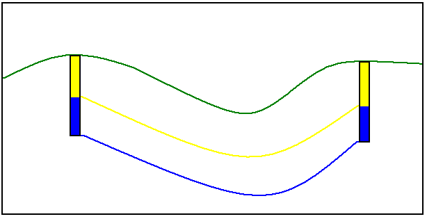
● By Strata
Elev: This method will generate a strata surface by modeling
the strata elevation values from the drillholes. This strata
surface is independent of the existing ground surface.
● Place Drillhole
Prompts: If Depth is selected, then when you run Place
Drillholes you will be prompted for the depth of each strata in
your drillhole. If Thickness is selected, you will be prompted for
the thickness of each strata. If Dialog is selected, you will
go straight into the Place Drillhole dialog when you create a
drillhole.
● Default Last
Thickness: Will set the thickness of your bottom
strata to the same amount for all your drillholes.
Keyboard Command:
tk_chdef
Prerequisite: strata
information