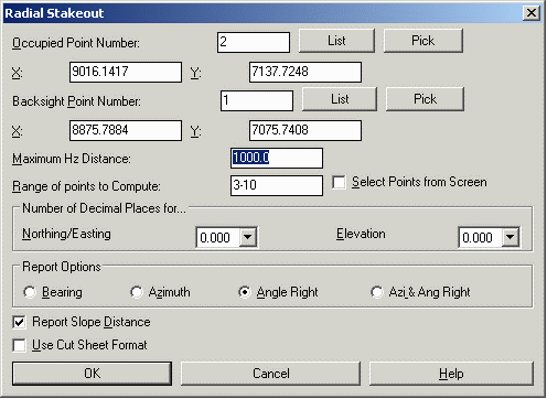
 Occupied Point Number:
Specify the occupied point number X and Y values will fill in
automatically.
Occupied Point Number:
Specify the occupied point number X and Y values will fill in
automatically.Backsight Point Number: Specify the backsight point number X and Y values will fill in automatically.
Maximum Hz Distance: This is the maximum horizontal distance from the occupied point that the program will include in the report.
Range of points to Compute: Enter the range of points to be included in the stakeout report If you check Select Points from Screen, this option is unavailable.
Select Points from Screen: This option allows you to select from the screen the points to be included in the stakeout report.
Number of Decimal Places: Specify the display precision for the report.
Report Options: Specify the direction format that the report should use.
Report Slope Distance: When checked, the slope distance is included in the report in addition to the horizontal distance.
Use Cut Sheet Format: When checked, adds columns to the report for Description, Hub Elev, and Elevation.

