This command will label the latitude and longitude of a selected
point. The program will convert the northing and easting of the
input points to latitude and longitude. There is an option to
include elevation in the labels. The coordinate system for the
drawing coordinates must be defined in Drawing Setup before running
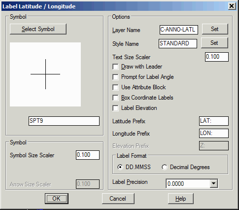
this command. First, the program displays a dialog box with options
to set the sizes, to set label prefixes, to set the display
precision, to draw a box around the label and to change the symbol
used to mark the point. When Draw With Leader is active, the
program prompts for the point to label and then the label location
and draws a leader between these points. When Draw With Leader is
off, the specified symbol is drawn at the point and the label is
drawn automatically to the size. The Prompt For Label Angle
option prompts for the label rotation instead of automatically
drawing the label horizontal. For the Use Attribute Block
option, the symbol must be a block with three attributes for the
latitude, longitude and elevation that the program will place and
fill out the attributes instead of creating text labels. After the
options dialog, the program prompts for the points to label. As you
move the cursor, the program display the latitude/longitude in
real-time.
Label Latitude /
Longitude dialog
Pick point or point number: pick a point
Pick point or point number: press Enter to
end