This command creates a slope stake report using cross section
data with stations, offsets, elevations and descriptions. The
program uses the data point descriptions to identify and catch and
pivot points and other data points to report. Besides processing a
section file (.sct), the program also uses a centerline file (.cl)
for reporting coordinates for the data points.
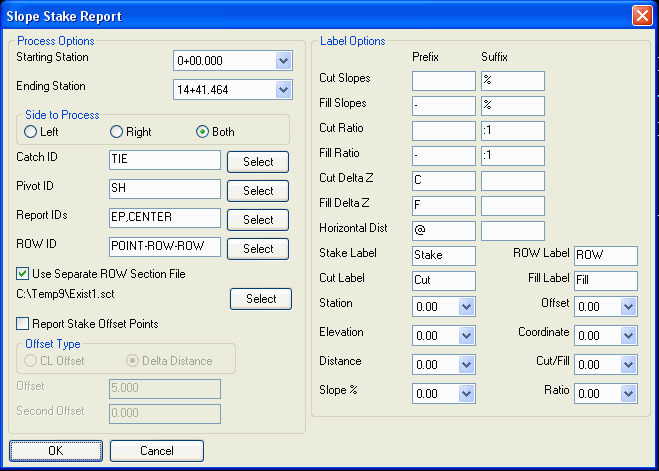
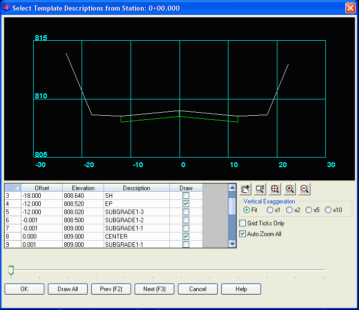
After selecting these files, there is a dialog for the report options. The Starting and Ending Stations control the range of stations to report. The Side To Process option selects whether to report the slope stake for the left or right of the centerline or both sides. The Catch ID is the section data point description for where the section ties into existing ground. The Pivot ID is the description for the hinge point at the beginning of the cut/fill slope. The Catch and Pivot ID's are required for the report. The Report ID's are optional additional section break points to include in the report. They should be entered in outside template to inside order. The Select button shows a graphic of the section data with toggles to select which section points to report. You can pick any combination of surface or subgrade points. Don't include the Catch ID or Pivot ID in the Report IDs because those IDs are already reported. The ROW ID is optional for including the ROW in the report. Typically, the ROW data is in the existing surface sections instead of the final sections. In this case, the Use Separate ROW Section File option can be used to specify the section file with the ROW data. The Report Stake Offset Points option adds an offset point that can be used for stakeout. The offset amount can be relative to the catch point or to the centerline. A second offset can be used for orientation with the first offset. The program reports the distance from the offset point to the catch point.
The Label Options section has prefix and suffix settings to add to the report values. There are also settings for the labels to use for the Stake, ROW and Cut/Fill names. There are also controls for the decimal places for the report values.
After specifying the options, the program uses the Report
Formatter to generate the report. The available fields are point
name, station, offset, northing, easting, elevation, cut/fill
label, horizontal distance, vertical distance, slope percent and
slope ratio. You can select which fields to report and their order.
The field labels and decimal precision is controlled by the Report
Formatter. The report can be output to the Report Viewer or
Excel.
Slope Stake Report
Sections: C:\sample\road.sct

Centerline: C:\sample\demo3.cl
Station: 0+00.000

From Name    To Name Horizontal Vertical Cut/Fill Slope%  Ratio

Stake Offset TIE     5.000      0.000    Flat     0.00    999.900

TIE          SH      5.255      5.255    Cut      100.00  1.000

SH           EP      6.000      0.120    Cut      2.00    50.000

EP           CENTER  12.000     0.480    Fill     4.00    25.000


You can also use the Mirror the columns option in the Report Formatter to layout the report like this:

Sections: C:\sample\final.sct

Centerline: C:\sample\demo.cl


Station: 0+00.00

CP      SH      EP      CENTER  EP      SH      CP

-19.53  -18.00  -12.00  0.00    12.00   18.00   19.53

1038.19 1038.57 1038.45 1038.69 1038.45 1038.57 1038.19

-25.00% 2.00%   -2.00%          -2.00%  2.00%   -25.00%

F 0.38  C 0.12  F 0.24          F 0.24  C 0.12  F 0.38

@ 1.53  @ 6.00  @ 12.00         @ 12.00 @ 6.00  @ 1.53
Section File To Process
Select a .sct
file.
Centerline File To Process
Select a .cl
file.
Slope Stake Report dialog
Choose report
options.
Report Formatter dialog Configure and display report.
Pulldown Menu Location: Sections > Section
Utilities
Keyboard Command: ssreport
Prerequisite: A section and a centerline file