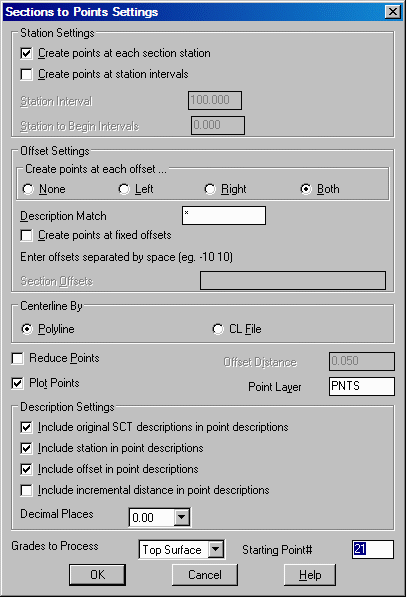
This command creates Carlson points using a section (.SCT) file
to define the point elevations. The x,y position of the points are
calculated based on the station and offset along a centerline
polyline. These points are stored in the current coordinate (.CRD)
file and can also be plotted in the drawing. Points can be created
at each station in the section file or at a set station interval.
The range of stations to process can also be set. The Description
Match field can be used to filter the offsets and only create
points with matching descriptions (e.g. only "EOP" offsets). The
Create points at fixed offsets option can be used to make points at
user-specified offset distances. The program will interpolate the
elevations for these points by interpolating from the neighboring
offsets. The is both a Centerline by Polyline or by CL File option.
The CL File option will prompt for an existing centerline (.CL)
file. The Reduce Points option will skip creating points for the
same offset between stations if the x,y position and elevation
change is less than the offset tolerance. Essentially, when a
series of offsets are on a straight line (no vertical and no
horizontal curve) then only the starting and ending points are
needed and all the intermediate points can be skipped. For example,
the Reduce Points routine will look at the left side EOP offset
points at stations 1+00, 1+05 and 1+10 and if these three points
make a straight line then the point for station 1+05 can be
reduced. The Offset Distance is the tolerance that Reduce Points
using for testing whether the middle point (offset point at station
1+05) can be reduced. The distance for the middle point is
calculated as the perpendicular distance from the middle point to
the line between the two end points. Both the horizontal and
vertical distances are checked.
Sections to Points Settings dialog
Coordinate File to Process Choose a .CRD or other coordinate
file to add the points to. This prompt only occurs if no coordinate
file is current.
Choose SCT file to read pick the cross section file
Range of stations: 3.34 to 750.00
Enter the starting station to process <3.34>: press
Enter
Enter the ending station to process <750.00>:
press Enter
Select centerline polyline: pick the polyline that
defines the stations
Type of centerline [<ROadway>/RAilroad]? RO
Enter the centerline starting station <0.0>: press
Enter
Created 65
points.
Keyboard Command: sctopt
Prerequisite: A .sct file and polyline centerline