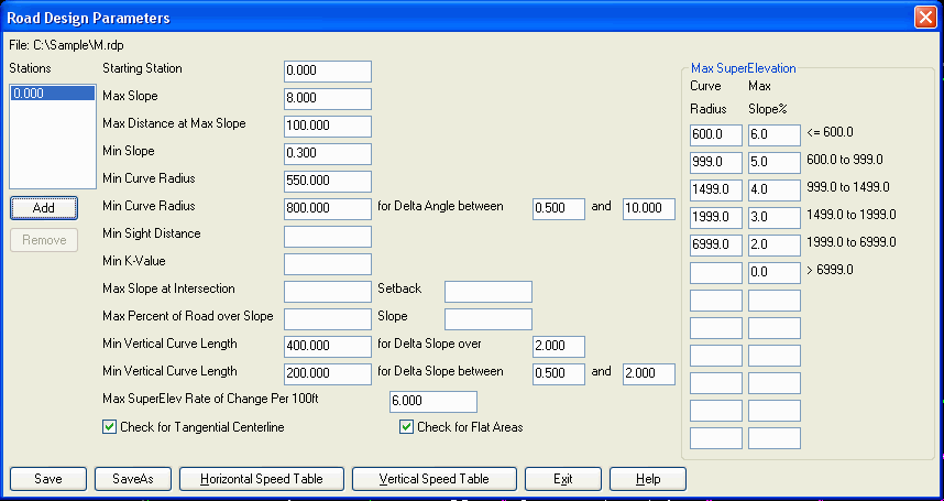
Define Road Design Parameters
This command defines design parameters that can be checked
against a road design with the Process Road Design and Road Network
commands. Only fill in the parameters to have checked. If you leave
a parameter blank, then that parameter is not checked. You can have
a different set of parameters for different stations along the road
in case road conditions change such as different speed limits. The
different sets of parameters are listed by station on the left of
the dialog. Use the Add button to add a new parameter set and use
the Remove button to remove the set highlighted in the station
list. To view a parameter set, pick the station in the Stations
list. If you don't need different sets of parameters, then leave
the Starting Station as zero and don't add other stations.
Starting Station: This is the station to begin using the
current set of design parameters.
Max Slope: This is the
maximum profile slope percent that is allowed.
Max Distance at Max Slope:
This is the maximum continuous distance that the profile can be at
the max slope.
Min Slope: This is the
minimum profile slope percent that is allowed.
Min Curve Radius: This is
the minimum horizontal curve radius for the centerline.
Min Curve Radius for Delta Angle
Range: This is the minimum horizontal curve radius for the
centerline for curves with a delta angle in the specified range.
Enter the delta angles in decimals degrees from low to high.
Min Sight Distance: This is
the minimum sight distance for the profile.
Min K-Value: This is the
minimum k-value for the profile.
Max Slope at Intersection:
This is the maximum profile slope at an intersection with another
road. The Setback is the
distance along the profile from the intersection point that this
max slope applies. This option only applies to Road Network.
Max Percent of Road over
Slope: This is the maximum percent of the road that can be
over the specified Slope.
Min Vertical Curve Length for
Delta Slope over: This is the minimum vertical curve length
for PVI's with an algebraic grade difference greater than the
specified Delta Slope. The Delta Slope units are in percent
slope.
Min Vertical Curve Length for
Delta Slope between: This is the minimum vertical curve
length for PVI's with an algebraic grade difference between than
the specified Delta Slopes. Enter the delta slopes in percent slope
format from low to high.
Max SuperElev Rate of Change Per
100: This is the maximum rate of change in the
superelevation for the cross slope. The rate units are in percent
slope per 100 feet or meters depending on your drawing units.
Check for Tangential
Centerline: This option checks the horizontal alignment to
make sure all the segments are tangential.
Check for Flat Areas: This
option checks the superelevation at the Run-In and Run-Out stations
where the outside lane is flat and warns if the profile is also
flat at those stations.
Max SuperElevation: This is
the maximum superelevation cross slope at full super for different
curve radii. A lookup table of curve radius and max slope is used.
The curve radii should be entered from low to high.
The Horizontal and
Vertical Speed Tables are
for referencing values to fill in for the design parameters.
Pulldown Menu Location: Roads
Keyboard Command: rdparam
Prerequisite: None