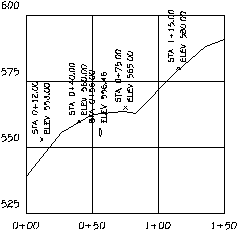
This command has two methods for placing points on a profile. One method places symbols on an existing profile at picked points or at entered stations and elevations. The station and elevation of the current position of the crosshairs is displayed in the lower right of the screen menu. The symbols can be any of the point symbols or a special pipe crossing circle that will become an ellipse to represent any vertical exaggeration.
The other method will draw an entirely new profile based on
points that are defined in a coordinate (.CRD) file. The elevations
of the profile come from the elevation of the points and the
stations come from the station value in the description field of
the point. Points without the station value in the description
field and points with a zero elevation are ignored. In addition to
drawing the profile, the points are plotted on the profile along
with their point number, elevation, and description. The station
text in the point descriptions can be generated with the
Calculate Offsets command in the Centerline menu. Using
SurvCE, the Carlson data collection program, you can gather points
in the field and store their station as the beginning of the
description, and these points would then plot as a profile using
this command.
Place points from CRD file or pick points
(File/<Points>)? pick
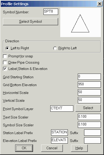
Profile Settings dialog
Pick lower left grid corner <5000.0,5000.0>: pick the
grid corner
Enter station or pick a point (Enter to End): 75
Elevation of point: 565
For CRD File option:
Select CooRD File to Read
This is the source file that contains the profile information.
Range of Point Numbers to use (A for All) <A>:
press Enter
Wildcard match of point description <*>: press
Enter
Plot Full or Abbreviated text (Full/<Abbrev)?
Full
Range of stations: <134.41 - 938.31>
Starting Station <134.41>: press Enter
Ending Station <938.31>: press Enter
Profiles Settings Dialog
Starting/Datum Elevation of Profile <495.0>: press
Enter
Pick Starting Point For Axis <100.0,495.0>:
press Enter
|
| Points placed on profile with a pipe crossing at station 56 |
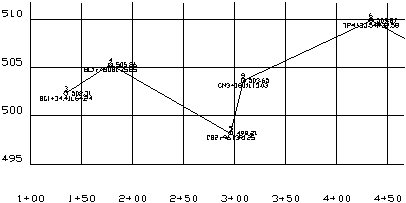
|
| Grid, profile, and points drawn by Point Placement on Profile |
3, 4368.47, 4250.26, 502.31, BC1+34.41L64.24
4, 4406.95, 4273.95, 505.26, BC1+78.08L75.85
5, 4427.67, 4416.11, 498.21, CB2+96.13R1.25
6, 4436.55, 4549.39, 509.87, TP4+33.54R32.58
7, 4566.77, 4795.20, 515.50, MH7+07.05L55.04
8, 4572.69, 4996.60, 520.14, MH8+88.55R43.18
9, 4446.17, 4419.49, 503.65, CM3+08.11L13.03
10,4506.57, 4814.72, 505.00, EPL7+04.50R8.18
Pulldown Menu Location: Profiles > Profile
Utilities
Keyboard Command: ptpro
Prerequisite: A .CRD file including points with elevations
and station information in the description field