Calculate Pond/Pit Volume
This command is a customized and simplified method for
calculating volumes in a situation in which the entire volume to be
calculated is below the perimeter elevation, such as in the case of
a pond or pit. The complimentary command, Calculate Stockpile
Volume, is for the opposite situation, in which the entire
volume to be calculated is above the elevation of the
perimeter.
The program internally computes BASE and FINAL grid surfaces
from drawing geometry. The base surface is calculated from a 3D
polyline representing the perimeter of the area being analyzed. If
that 3D polyline is drawn on the PERIMETER layer, the command will
automatically detect and use it. If no 3D polyline is found on that
layer, you have an opportunity to manually select the 3D polyline
to use. The 3D polyline perimeter can be drawn with the
Draw 3D Polyline Perimeter
command before using this routine.
The 3D polyline perimeter is also used as the inclusion
perimeter for the volume calculation.
Additional 3D polylines can also be specified to more precisely
define the BASE surface. These must be on the BASE_BREAKLINE
layer to be used for this purpose. These can be generated by the
Draw 3DPoly Base Breakline routine.
The FINAL surface is calculated from all of the other selected
drawing entities such as points, line, inserts, and polylines,
along with the perimeter polyline, but not including the BASE_BREAKLINE
polylines. These features are used only in computing the
BASE surface.
You have the option of setting the resolution of the
grids.
Besides reporting the entire volume between the two surfaces,
the report also includes the volumes at an elevation interval from
the bottom to the top. These stage-storage volumes can also be
stored to a capacity file (.cap) that can be used with the
Hydrology module. In addition to the stage-storage volumes, the
Report Incremental Volumes
option reports the storage within an elevation range instead of
relative to the surface.
The Make 3D Grid File and Two Grid Surface Volumes
commands, used in combination, are an alternative to this command,
and in any situation in which there are both cut and fill volumes
between the surfaces, that combination must be used to generate
accurate results.
Prompts
Ignore Zero Elevations [<Yes>/No]? press Enter
Select Pond/Pit entities and perimeter.
Select objects: pick the objects that define the surface and
the 3D polyline perimeter
Select Pond/Pit perimeter polyline: pick the polyline
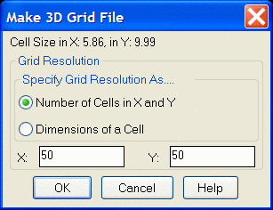 Make Grid File dialog Set the
resolution and then click OK.
Make Grid File dialog Set the
resolution and then click OK.
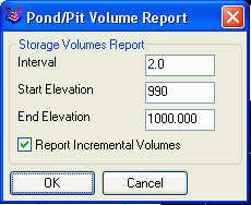 Sample
Volume Report:
Sample
Volume Report:
Lower left grid corner : 8361.29,10856.76
Upper right grid corner: 8940.96,11302.31
X grid resolution: 50, Y grid resolution: 50
X grid cell size : 11.59, Y grid cell size: 8.91
Pond/Pit volume : 602,182.5 C.F., 22,303.06 C.Y., 13.82 Acre-Ft
Area: 114,312.7 S.F., 2.624 Acres
Elevation Range: 987.08 to 1000.00
Storage Volumes
Elevation Storage(AcreFt)
(C.Y.) (C.F.)
Area(Acre)
990.00
0.26121
421.4 11378.5 0.281
992.00
1.18631
1913.9 51675.9 0.646
994.00
2.85639
4608.3 124424.4 1.033
996.00
5.46346
8814.4 237988.4 1.591
998.00
9.13982
14745.6 398130.8 2.083
1000.00
13.82421
22303.1 602182.5 2.624
Increment
Storage(AcreFt) (C.Y.)
(C.F.) Area(Acre)
990.00-992.00
0.92510
1492.5 40297.4 0.365
992.00-994.00
1.67008
2694.4 72748.5 0.387
994.00-996.00
2.60707
4206.1 113564.0 0.558
996.00-998.00
3.67636
5931.2 160142.4 0.492
998.00-1000.00
4.68438
7557.5 204051.7 0.541
Pulldown Menu Location: Surface >>
Stockpile/Pond/Pit Volumes
Keyboard Command: pitvol
Prerequisite: Data representing the pond/pit surface and a
3D polyline representing the perimeter of the
pond/pit.