This command allows you to set elevations to contours from elevation labels.
Select a sample of the elevation text to be used on the contouring. Next, select a sample of the contouring that you want to add the elevations to. Now select all the contours and their corresponding elevation labels and press Enter. Carlson Civil will then add elevations to all the contours. You may be prompted to distinguish what contour goes with what elevation label. You can either press Enter to accept the contour that Carlson Civil has selected or you can Press N to choose another contour.
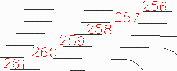
Select sample of elevation
text: pick an example text
elevation
Select sample of a contour
line: pick an example
contour polyline
Select contour lines and elevation
text to process.
Select objects: select the
entities to process
Joining adjacent polylines...
Reading the selection set ...
Joining ...
Pre-processing entity #1008 of 1008
Filtering text entities
Processing elevation text #518
Conflict detected: pick
contour corresponding to current elevation text
Press N for next selection or
Enter to accept current:
Remaking polyline #311
Pulldown Menu Location: 3D Data > Assign Contour
Elevations
Keyboard Command: txtcelev
Prerequisite: Contours and contours labels