This command is designed to allow the user to create HEC-2 input files. HEC-2 is a computer program prepared by the Corps of Engineers to compute water surface profiles in non-prismatic stream and river channels. The bulk of the input to the HEC-2 program consists of cross-sectional data of the stream and adjacent flood plain. It is in the preparation of this data that Carlson can be of real assistance.
The Prepare HEC-2 Input File routine converts *.sct files prepared in Carlson to HEC-2 input data. The files are given the same name as the *.sct file used to make them and are given the *.h2i file extension. Each line in the HEC-2 text file begins with a two letter identifier, followed by the corresponding data in a fixed format. Each segment of the stream is represented by a group of lines. The header for the section is the "X1" line. On this line is recorded the general information about the section and the channel reach. The "X1" line may be preceded by several change channel lines. "NC" cards are the only representative of the change lines in this routine. This line defines the stream frictional resistance by the Manning's n. The "X1" line is followed by a series of "GR" lines representing the ground at the section. This representation is a list of elevations and distances from a baseline. The baseline is on the left side facing downstream and the distances are positive values, increasing as the section is read from left to right.
Sections are identified in HEC-2 by a 6 character identifier on
the "X1" line. The sct2hec conversion program uses the integer
value of the centerline station as the identifier for the section.
This allows sections at stations up to 9,999+99. This corresponds
to study reaches of 189 miles. For the sake of standardization
horizontal distances along the section are taken to the even foot
and elevations to the 0.1 foot.
The next piece of information on the "X1" line is the number of points on the following "GR" cards. The limit of 100 points in HEC-2 is checked and an alert box generated if applicable. The next two items of data on the "X1" card are the stations of the left and right banks of the stream. In HEC-2 the points must be points on the GR cards. Therefore these entries are made by selecting points from the list of points.
The last data on the "X1" line is the lengths of the channel and overbanks within the reach from the prior section to the current section. The distance between the sections is determined by the difference in stations of the sections on the *.sct file. This distance is presented as the default value for the length of both overbanks and the channel. On the first section these three values are 0, which tells HEC-2 to begin a profile. If the original polyline defining the *.mxs file was along the thalweg of the channel then the channel length default is correct. The overbank lengths should be edited for curves in the channel.
A Carlson *.sct file may be made by any one of the seven methods listed on the Sections pull-down of the Civil Design module. A *.sct file made by any of these procedures can be converted to a *.h2i file. The procedure to create an *.sct file from a surface model begins with establishing a polyline as the centerline by which the sections will be oriented and spaced. This should be along or near the thalweg, or center of flow, of the stream and drawn in an upstream direction. From this polyline a *.mxs file is created. The width and location of sections at regular intervals and at special stations are defined in this step. It is this *.mxs file which Carlson uses to define the inundated regions latter in the hydrology modeling. Then the sections are cut and the *.sct file created by the normal means in Carlson. Carlson allows limiting the number of points in the section. Since HEC-2 has a limit of 100 points in a section, that limit should be observed when cutting the sections.
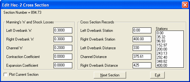
When running the convert a *.sct file to a *.h2i file, an input *.sct file is first requested by a file selection dialog box. Then a "Basic Applications for Hec-2" dialog appears requesting information useful for preparing the *.h2i output file. Then a dialog presenting each section as stations appears (shown above). The horizontal distances, called stations in HEC-2, along the cross-section must all be positive numbers increasing across the section. The HEC-2 section represents the ground as a left to right section looking downstream. For the HEC-2 computations the sections are read from the downstream end working upstream. Thus the need to begin the *.mxs file at the downstream end of the stream reach. (The preceding applies to the predominate case of subcritical flow and is reversed for analysis of supercritical flow.)
As each section is read the user is presented with a dialog box to edit data specific to each section. In the right half of the dialog box are edit boxes for the channel and overbank reach lengths. The distance between sections is used as the default in all three boxes. The user may edit these values to correspond to channel curvature or other conditions as hydraulically warranted. If the channel curves left, then the left overbank distance would be smaller and right overbank distance would be larger. There are also input boxes for the Manning's n coefficients for the channel and overbanks. The Manning's n values may be edited just like any edit box. The top of bank stations are assigned values by selecting points from the list of all the points in the section displayed along the right of the dialog box. The first station selected is assumed to be the left bank and the second the right bank. If the user changes his mind about the bank station, after the first two selections from the list the user can select either right or left bank. These boxes do not update their display until the user has selected another box to edit. The top of bank stations must correspond to points on the following "GR" cards, which is why user entry of any number is not allowed. The bank stations are used by HEC-2 to apply the Manning's n values assigned by the user.
A complete, but minimal, input file is created by this conversion routine. Certain default values were selected and written to the output file to make it a complete file. These are:
Begin computations using the slope/area method with 0.01 '/'
slope;
Only a single profile will be computed;
On the "T2" card the input *.sct file is recorded;
At each section the default top of bank stations are the first and
last points.
The user will normally need to edit the *.h2i file to represent the flows and conditions to model and the type of output desired. Other parameters which may be added to the input file (a few of which are included in the initial opening dialog) are:
Contraction and expansion coefficients for energy loss,
Multipliers to Manning's n,
Call printer plots,
Channel modifications,
Bridges by normal or special methods,
Custom output formats,
Ice conditions and
Encroachments.
All of these items can be entered into the file on the appropriate cards using the DOS Edit program, the Display-Edit selection in Carlson or a similar editor. The output of the conversion is in the fixed 80 column format expected by the HEC-2 program. If the user is making significant changes or additions to the data it may be advisable to use the FREE format option for hand entered data.
The default values for Manning's n are 0.020 in the channel and 0.030 for both overbanks. These can be edited for the first section and the edited values will apply to all following sections. Editing the values in latter sections will create a new "NC" line to be written ahead of that section.
The availability of easy input data to the HEC-2 program will change the way engineers use HEC-2. In the past the location and number of sections was carefully considered to get the best result with the fewest, most representative, sections. Now a common topographic survey of the channel reach can provide easily sections at close intervals. Changes to the stream geometry can be easily modeled in the site plan and converted to HEC-2 data for analysis. This practically eliminates the need for channel improvement "CI" lines.
Pulldown Menu Location: Watershed
Keyboard Command: sct2hec
Prerequisite: Cross section .sct file