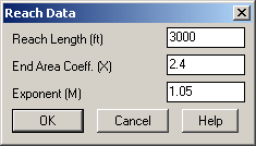
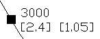
This command places a reach on a Flow Polyline of the watershed schematic for TR-20 Hydrograph Development. The program prompts for the reach length, end-area coefficient and exponent M. These variables are explained in the TR-20 manual. A square reach symbol that contains the reach data is drawn on the flow polyline. The reach labels show the length above the end area coefficient and exponent M.
Symbol size <4.0>:
Indicate the desired symbol size and press
Enter
Pick location on flow polyline for
reach: Pick a location for the reach
and press Enter
Pulldown Menu Location(s):
Watershed → TR-20 Routing
Keyboard Command: trreach
Prerequisite: Flow polyline