This command calculates the volume of sediment that can be expected from a watershed by soil erosion due to precipitation. It allows the user to specify multiple watershed areas, each with its own set of geometric and hydrological parameters. The Universal Soil Loss Equation (USLE) is used in calculating the soil loss. For each area, the area, slope and length can be manually entered by the user or it can be calculated by the program directly. For direct calculation of the geometric properties of the area, the user must have a grid file that models the surface. This can be created using the Make 3D Grid File command. In addition, the area must be defined by closed polylines for inclusion perimeter. Exclusion perimeters are optional for excluding areas from calculations.
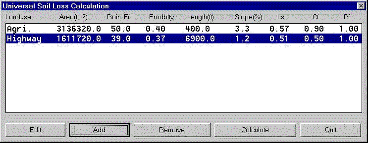
The program starts with the dialog below, where the user can add as many areas as needed to include in the USL calculation. Each area added is shown in the list box with all its parameters listed. To add a new area, click the "Add" button. To edit the parameters of an existing area, highlight that item and click the "Edit" button. To remove an existing area, highlight it and click "Remove".
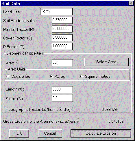
The "Edit" or "Add" button brings up the dialog box shown here, where the various parameters of the area can be specified or edited. The "Landuse" is just an identifier for the area and has no further significance. Soil Erodibility, K (tons/acre) is a property of the soil, which determines the amount of sediment resulting from a precipitation event in an area. The rainfall factor, R, is a dimensionless factor that accounts for the relationship between erosive forces of falling rain and runoff. The Cover factor, C, is a dimensionless factor that relates the effectiveness of vegetal cover in reducing erosion. The Topographical factor, Ls, is a dimensionless length slope factor that accounts for variations in length and slope in the area. The (Conservation) Practice factor, P, is a dimensionless factor to determine how landuse effects its erodibility.
If the area of the watershed is known and is entered manually, then the length and slope of the area have to be entered manually as well and the Ls factor will be calculated from these geometric properties. The area can also be calculated directly if the boundary is defined as a closed polyline and the grid file that models the surface is also made. The user clicks the button "Select area" and the program asks the user to select the grid file as well as the closed polyline representing the area. Then, the Ls factor and the slope are calculated by the program and displayed (the "length" is not needed in this case). After filling in all values, click on "Calculate USL" to calculate the soil loss rate per unit area for the area selected. The user can change the parameters corresponding to this are and recalculate, if needed. Click "OK" to return to the main dialog box. The area should now appear in this dialog box if the parameters as specified.
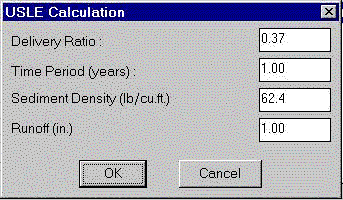
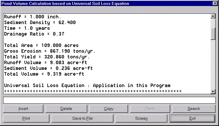
After all required areas are input, the sediment volume can be calculated by clicking the "Calculate" button on the main dialog. This brings up the USLE Calculation dialog box as shown here. Specify the Delivery ratio, which determines what portion of the gross erosion is actually left for deposition at the final destination, accounting for losses during sediment transport. Also, specify the Time period for which deposition has occurred. Specify the Density of the sediment, so as to be able to determine the volume of the deposit from its mass in tons. Also, specify the amount of Rainfall (inches or cm) for which runoff volume has to be calculated. The program then calculates the Runoff volume based on the total area and the amount of rainfall. It also calculates the sediment volume, using the Universal Soil Loss Equation (USLE) and adds it to the sediment volume and reports it as the total pond volume. A report of the form shown below is generated. This report also gives a detailed account of the calculations performed. For further information about the estimation of the various parameters used in this program or about the USLE, please refer to "Applied Hydrology and Sedimentology for Disturbed Areas" (1981), Barfield, B.J., Warner, R.C. and Haan, C.T., Oklahoma Technical Press.
Pulldown Menu Location: DTM in Hydrology
Keyboard Command: soilloss
Prerequisite: Use Make 3D Grid File to create a grid
file that models the surface