Set Rim Elevation to Match Surface
This command compares the rim elevations for the current sewer
network with the current surface model. If any differences are
found, the program shows a dialog box with the rim elevations,
surface elevations, structure names and elevation differences. You
can highlight structures from this list to update their rim
elevations to match the surface model. There are two update
methods:
Update Depth, Hold Invert: Keeps the invert elevations while
updating the rim elevations so that the depths are adjusted.
Update Invert, Hold Depth: Adjusts the invert elevations by the
same amount as the rim elevations so that the depths are
maintained.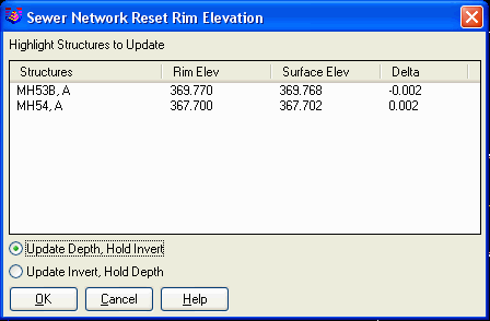 Pulldown Menu Location: Network->Sewer
Network Utilities
Pulldown Menu Location: Network->Sewer
Network Utilities
Keyboard Command: swrsurf
Prerequisite: sewer network structures