Define Isopach Maps Auto-Run
The Define Strata Isopach Auto-Run is
for building the macro auto-run file containing the isopachs to
create. There is still the option to run the auto-run from here if
desired. If there are not any drillholes, for example, you are
coming from grids, just hit Enter when prompted to select
drillholes.
The first dialog shows the defined
isopachs that will be created. There are buttons to Edit, Add and
Remove the row. The Sort will sort them in order. Up and Down will
move them up or down the list. The On or Off buttons turn them on
or off for processing. The Make Isopachs button starts the process
and creates the isopach maps. Load and Save/SaveAs will load
or create the CTR file. The two entry dialog boxes are slightly
different, depending on drillholes or grids.


Following is a description of all the items on the dialog for the
Auto-Run Isopach.
- Processing on:
This needs to be selected to
build the isopach. It controls the Process column on the first
screen.
- Strata Name: This will display the
strata name if isopaching from drillholes. If isopaching a grid,
then this will be blank.
- Value to Process: This is the attribute
or item to isopach. It can be an elevation, thickness or any
quality attribute. It will be grayed out if isopaching a grid
file.
- Contour Layer: Enter the layer for the
contours.
- Color: Choose a color for the contour
layer.
- Contour Interval: Enter a contour
interval . This is for the intermediate contours. Index contours
are set below.
- Smooth Contours: This toggle will
determine if the contours are smoothed. The slide bar controls the
smoothing from Low to High.
- Smoothing Sub-Division Levels: The
smoothing subdivision option will internally subdivide the grid
cells with a quadratic smoothing algorithm to help create smoother
contours.
- Reduce Vertices: This option removes
vertices from the contour lines, as long as the contour line does
not move more than the Offset Distance from the original
location.
- Drawing File: There is the option to
output each isopach map to its own drawing file. To do this, just
select the Choose Drawing File button and enter a drawing name.
This name is displayed above the button. If this is not selected,
then the isopachs are drawn in the current drawing.
- Grid File: The Choose Grid file button
is active only if the Modeling Method is set to Grid File. The grid
to isopach is displayed above the button.
- Modeling Method: There is the option to
model the drillholes by Triangulation, Inverse Distance to any
power, Kriging, Polynomial and Least Squares. Using a premade grid
file is also set here if the drillholes are not used.
- Draw Index Contours: Turn this option
on to generate the index contours.
- Set Index Options: This brings up the
Index contour options screen to set the interval, width, layer and
color shown below.

- Label Contours: This option will label the
contours.
- Set Label
Options: This button will bring up the Contour Label Options
screen shown below.

- Ignore Zero Values: This option will ignore any zero values for
contouring.
- Range: Min
Z and Max Z: This defines the low and high values that will
be contoured. Any values outside of this range will not be
contoured.
- Use Triangulation Subdivision: When
modeling with Triangulation or Polynomial, this will subdivide the
triangles into at least 3 smaller triangles for smoother
contours.
- Extrapolate Grid To Full Grid Size:
When modeling with grid files, this option will extrapolate to
assign values to any null cells in the grid file.
- Use Global Trend Extrapolation: When
modeling with Triangulation or Polynomial, this will extrapolate to
the edge of the grid limits based on the overall global trend.
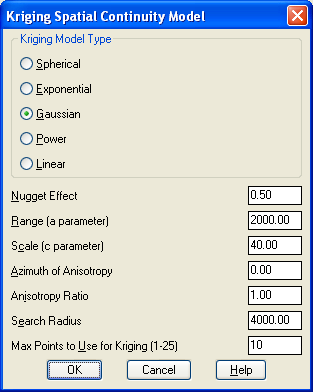
- Set Kriging Parameters: When modeling
the drillholes with Kriging, This button brings up the Kriging
Spatial Continuity Model settings screen shown below.
- Inverse Distance Power: When modeling
the drillholes with Inverse Distance, this is the power that the
distance is raised to. It can be any power, including
decimals.
- Elliptical Inverse Distance: If the ore
body is long and narrow, sometimes an elliptical inverse distance
modeling method is preferred. This option will allow for two
different powers to create an ellipse.
- Anisotropic Azimuth/Factor: When using
the Elliptical method, this is the azimuth for the second factor,
and the second factor power.
Prompts
Select drillholes, channel
samples and strata polylines or ENTER for None. Select Enter
if isopaching only grid files.
Select objects:
all
61 found
Select objects:
Reading drillhole 194
Finding splits ...
Finding pinch out ...
Calculating seam stacking ...
Select the Inclusion perimeter polylines or ENTER for none.
Select the Exclusion perimeter polylines or ENTER for
none.
Pulldown Menu Location:
StrataCalc
Keyboard command:
chiso2
Prerequisite: Drillholes or
grid files