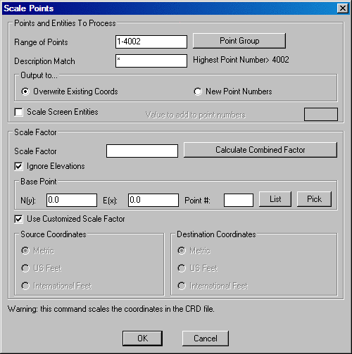
This command scales points in a coordinate file. The northing, easting and optionally the elevation are multiplied by the specified scale factor. You can use this routine for Metric-English conversion or a specific conversion by choosing the Use Customized Scale Factor option and specifying the desired Scale Factor in the edit box.
Specify the Range of
Points to scale by entering in a range or group to scale.
You can access the group dialog box by typing "group" in the range
of points field.
The Description Match option only scales points with the description(s) specified in this field.
The Scale Factor is to be entered in manually when using
a customized scale factor. If converting from standard measurement
units, feet to meters, meters to feet, US Feet to International
Feet, etc., the scale factor will be calculated and entered
automatically. If a combined scale factor is required for
converting from ground to grid and grid to ground coordinates, this
value can be calculated by using the Calculate Combined Factor option. The
Combined Factor is the Elevation Factor times the Grid Factor. This
calculation process begins with the Calculate Scale Factor dialog
shown below.
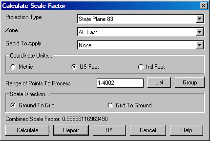
The Projection Type must be specified as either State
Plane 83 or State Plane 27 as well as what state plane Zone
is required.
The available Coordinate Units are Metric, US Feet and
International (Intl) Feet. The correct unit must be specified
before calculating the combined scale factor.
The Range of Numbers to Process should be used to select
the points to be used in order to calculate the combined scale
factor. This does not specify what points are going to be scaled by
the resulting scale factor. These points can be selected from a
list by selecting the List button.
Scale Direction determines which way the scale factor
will be calculated. A scale for Ground to Grid or Grid to
Ground can be calculated and applied.
Pressing the Calculate button will calculate and then
display the combined scale factor on the dialog box. To accept this
value as the customized scale factor to use to scale the points in
the coordinate file, press the OK button.
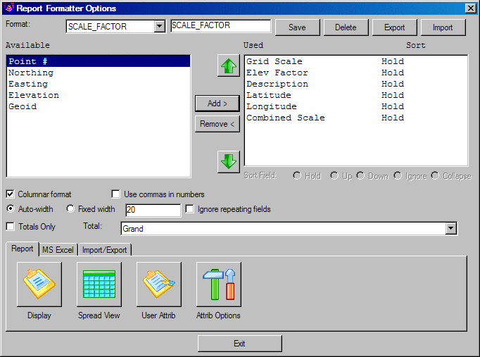
The Report option displays a report showing specified
information. This information is specified by using the report
formatter found throughout the program. Simply choose the
information you wish to display and the order to be displayed. For
further instruction and information on the Report Formatter please
refer to the Report Formatter section of this manual.
With Align Scale Entities checked ON, after specifying
the point range or group to scale and selecting OK on the dialog
box the following command line prompt is displayed:
Select objects to scale (points excluded):
At this prompt select the objects on the screen, polylines, lines,
arc, etc., to also scale and press enter. The points and screen
entities will be now be scaled and updated graphically and in the
active coordinate file.
With Use Customized Scale Factor Off, various conversions
can be performed by specifying the Source Coordinate units and the
Destination Coordinate units. This is a quick and easy way to
perform Metric/English conversions.
Pulldown Menu Location: Points
Keyboard Command: scalept
Prerequisite: points in a coordinate file