Best Fit Curve
This command draws an arc between two endpoints with a radius
that is derived from sampling points. Least-squares is used to find
the radius for the closest arc that passes through these points.
After specifying the points, the program calculates the best-fit
arc and shows the results in the dialog show here. You can toggle
each point for whether to include in the calculations. When a point
is toggled off for processing, it is not used to calculate the
best-fit arc but the residual is still reported. Use the Remove
button to remove a point both from calculation and reporting. You
can also modify the radius. After picking OK, the arc is drawn in
the current layer and there is a report.
Prompts
Starting Point ?
Pick point or point number: 46
Ending point ?
Pick point or point number: 50
Select points from screen, group or by point number
[<Screen>/Group/Number]? press Enter
Select Carlson Software Points.
Select objects: W Use window to select a group of
points. After selecting all the points to sample, end selection by
pressing Enter.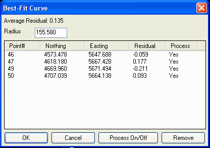 Best Fit Arc
Coordinate File> C:\sample\PLAT.CRD
Source Coordinates
Point# Northing
Easting Residual
46 4573.478
5647.688 -0.059
47 4618.180
5667.428 0.177
49 4669.960
5671.494 -0.211
50 4707.039
5664.138 0.093
Residuals Standard Deviation: 0.148
Average Residual: 0.135
Circle Center: 4657.233,5516.647
Radius: 155.580
Pulldown Menu Location: Draw > Arc
Keyboard Command: bfitcrv
Prerequisite: Points for sampling should be drawn before
execution.