
This command labels selected Object Data fields within MPolygon
areas with smart rules for different methods to handle any labels
that overlap the area perimeter. This command requires AutoCAD Map
2006. The program starts by prompting for the object data table
name at the command line. To check the object data table name of an
MPolygon entity, double-click on the MPolygon to bring up the
Properties dialog. In the dialog, object data is shown in sections
labeled OD:Object Table Name.
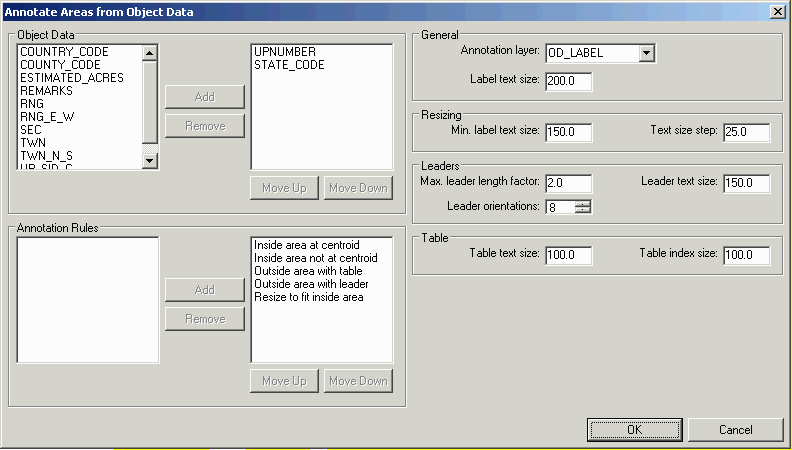
After selecting the object table name, there is an options
dialog. The dialog lists all the field from the object table and
you can select which fields to label by adding them to the list on
the right. The Annotation Rules are used to position the labels.
The rules are applied in order until the labels fit inside the
MPolygon. You can choose which rules to use and their
precedence:
Inside Area At Centroid: Places the labels at the centroid of the
MPolygon
Inside Area Not At Centroid: Searches for any space inside the
MPolygon that fits the labels.
Resize To Fit Inside Area: Places the labels at the centroid of the
MPolygon at smaller text sizes. The options for this rule control
the minimum size to use and the size increments to try starting
from the initial size.
Outside Area With Leader: Places the labels outside the MPolygon
and draws a leader from the label to the MPolygon center. The
options for this rule control the max length of the leader as a
factor of the text size, the size of the leader arrowhead, and the
number of directions to try as leader positions.
Outside Area With Table: Places the labels in a separate data table
and a data id label inside the MPolygon. The settings for this rule
control the size of the table and the id label.
Pulldown Menu Location: GIS Tools
Keyboard Command: label_area_obj
Prerequisite: MPolygons with object data