|
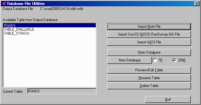
| Initial dialog at start of command with primary functions |
This command is designed to import GIS data from SurvCE, GISCE and FAST Survey files, as well as from user-defined text/ASCII file fields. It also exports data from Carlson Note files (.NOT or .VTT) to Microsoft® Access (.MDB) database tables. The .NOT extension is used when data transfers from desktop. The .VTT extension files are data transfers from data collector.
Note files are associated with Coordinate files (.CRD) and contain additional data for point numbers. For example, the Coordinate file for a manhole point could contain the point number, northing, easting, elevation and 32 character description, while the corresponding note file for that point contains additional data on the manhole such as diameter, depth, condition, etc.. A Carlson Note file for a Coordinate file will have the same name as the Coordinate file, except with a .NOT or .VTT extension instead of the .CRD extension (e.g. PARK.NOT goes with PARK.CRD). The Carlson Note file is a text file which consists of a point number (PT_ID) followed by field names with values. This group of point number and fields can also have a GIS_FILE name, which is used to identify this group of fields. This GIS_FILE name comes from the Note file prompting definition file (.GIS), which defines the field names for the group and is created in the Define Note File Prompts command.
You can select the Note file to process by using the Import Note File button. The program will then list all the GIS_FILE names that were found in the Note file. If a set of data for point number does not have a GIS_FILE name, then this group will appear in the list as UNKNOWN.
The name of the Microsoft® Access database to add the data to is the output database file, listed at the top-left of the Database File Utilities dialog. You can change the output database by using the Open Database button and selecting an existing database, or by clicking New Database to create a new database. The database tables will automatically have the same name as the GIS_FILE. This dialog also allows you to preview and edit a spreadsheet editor, which in turn allows you to modify values in the table. Each set of note file data for a point is displayed on one row with the corresponding record from the database shown on the next row. You can export the Note file data and create a new Access database .MDB file, in Access '97 format or in Access 2000 format, by doing a SAVEAS into .MDB format. You can rename and delete a table as well.
Database File Utilities can be combined with the Create Links command to make GIS links between the point entities in the drawing and the Microsoft® Access database records. The point entities can be drawn with the Draw/Locate Points or Field to Finish commands.
|
|
| Initial dialog at start of command with primary functions |
Available Table from Output
Database: Selection list. Pick a table from the Output
Database.
Import Note File: Imports a Carlson Note File (.NOT).
Import SurvCE/GISCE/FastSurvey GIS File: Imports a
SurvCE/GISCE/FastSurvey Note File.
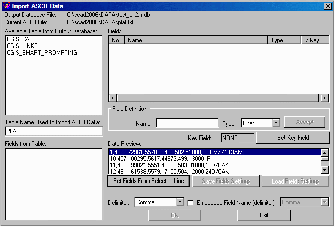
Import ASCII File: Imports ASCII file.
Open Database: Opens Access database .MDB file.
New Database: Creates a new Access database .MDB file in
Access '97 format or in Access 2000 format.
Preview/Edit Table: Displays a spreadsheet editor, allowing
you to preview/edit values from table.
Rename Table: For renaming a table as needed.
Delete Table: For deleting a table as needed.
Current Table: Displays the selected table from above
list.
|
|
| Dialog seen after choosing Import ASCII File and selecting file name |
Pulldown Menu Location: GIS Data
Keyboard Command: noteutil
Prerequisite: A note file (.NOT from desktop or .VTT from
data collector)