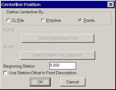
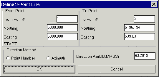
This function determines the station and offset relative to a centerline for a point. The centerline can be defined by a centerline file (.CL), a points, or by a polyline. The centerline file can be created with commands in the Roads menu. One advantage of centerline files is that it allows you to use profile files which can report cut/fills. For the points method, you can either give two points or a starting point and azimuth. The points can be defined by a point number from the current coordinate file or by simply entering the northing and easting. The first dialog for Centerline Position has the choice for centerline file or points method. With the centerline file option, the dialog shows the last centerline file name used. If this file is correct, then click OK. Otherwise use the Select button to choose the centerline file name.
Light bars are useful for left-right guidance. To enable the light bar option go to Configure Field, then to Centerline Position Settings and pick Use Light Bar.
Centerline Position with GPS
Carlson Field will continually read your current position from
the GPS receiver. A dialog box appears displaying your current
position. Carlson Field finds and displays in the dialog the
station/offset for this point.

An arrow icon will appear on the drawing showing your location. You can move along the centerline and Carlson Field will report the station/offset in real-time. If you move beyond the ends of the centerline, then the program will stop reporting station/offset and instead will report "Off CL".
The Store button will create a point at the current position. The default description will include the current station/offset. When Store is selected, a dialog box will appear for entering the point number and description.
Centerline Position with Total Stations
Centerline Position uses a dialog box that is very similar to the Point Store dialog. Under the Setup button, make sure that the occupied point, backsight and instrument height are set. Then have your rodman set the prism over the point you are interested in. Pick Read(F1) or Read & Store(F5) and the total station will take a shot.
After the shot is taken, the dialog box looks like the one at right. Carlson Field reports the current coordinates and the station/offset. The station/offset also appears in the Desc box. If you click Store, Carlson Field will record this point and plot it on the drawing, including the Desc as a label.

Pulldown Menu Location: Roads
Prerequisite: None