CURRENT INFORMATION
The Current Information Dialog Box contains information on:
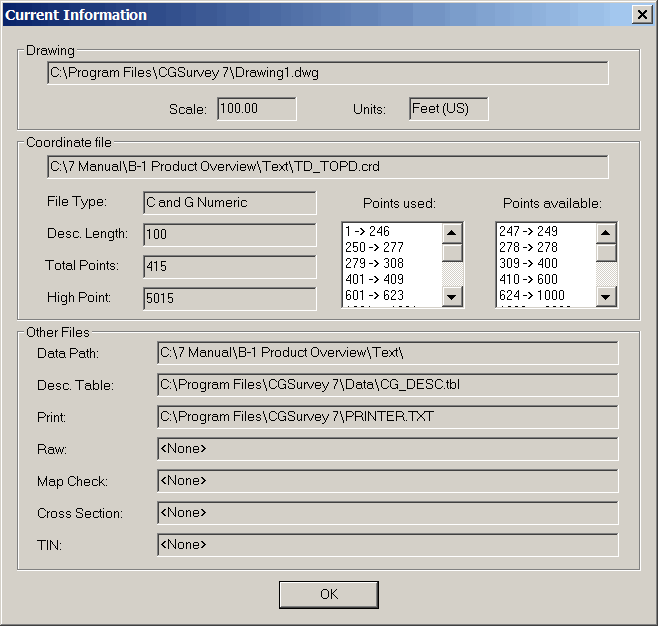
Drawing: displays the current drawing file Path, Name, Scale, and
Units
Coordinate File: displays the current coordinate file path and
names.
File Type: This will display the
current Coordinate file type.
The file types are:
C&G Numeric (.CRD) (PT #: 126)
C&G Alpha-Numeric (.CGC) (PT #: RW126)
Carlson Numeric (.CRD) (PT #: 126)
Carlson Alpha-Numeric (.CRD) (PT #: RW126)
Description Length: Numbers
of character in the description
Total Points: Total number
of points in the file
High Point: The highest
point number stored
Points Used and Points
Available: displays the block or blocks of points used or
available in the coordinate file currently open.
Other Files: Displays the
files that are currently open:
Data Path: displays the
current default path and coordinate file name
Description Table: displays
the current default path and description table
Print: displays the current
default path and Print file name
Raw: displays the current
default path and RAW file name
Map Check: displays the
current default path and Map Check file name
Cross Section: displays the
current default path and Cross Section file name
TIN: displays the current
default path and TIN file name
Pulldown menu
Location:CG-Survey > File
Keyboard Command:INF,
cg_current_info
Prerequisite: None