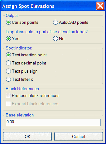
This command takes spot elevation entities with zero elevations and
assigns them elevations according to corresponding elevation labels.
This dialog box allows you to choose the format of the spot
elevations entities that you want to convert.
Output:
Carlson points: creates Carlson points at elevation of spot and
stores them in
coordinate file
AutoCAD points: creates
AutoCAD point objects at elevation of spot
Is spot indicator a part of the
elevation label?
If set to "Yes", four choices for Spot indicator are available to
select from:

Text insertion point: uses the insertion point of the text for
the location of the new point
Text decimal point: uses the
decimal point in the text for the location of the new point
Text plus sign: uses the plus
sign in the text for the location of the new point
Text letter x: uses the letter
x in the text for the location of the new point
If set to "No", five choices for Spot indicator are available to select from:
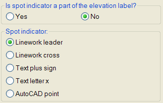
Linework leader: creates a data point at the end of a leader

Linework cross: creates a
data
point at the
intersection of a linework cross
Text plus sign: creates a data
point at the insertion point of a text plus sign
Text letter x: creates a data
point at the middle of a text letter x
AutoCAD point: creates a data
point at the node of an AutoCAD point
Block References:
Process Block References: If check box is cleared, Carlson
Civil searches only text entities for
elevations, but if checked, Carlson Civil will search block references
for elevations that are stored as attributes of a
block. Use this option if the elevation is an attribute and the
symbol designating the location of the spot elevation are both part of
the block definition.
Expand Block References: Use
this option to search block references when the elevation is stored as
an attribute of a block, but the symbol designating the location of the
spot elevation is a different block or even other geometry that is not
defined within a block.
Base elevation: The value
entered here is added to the existing spot elevations for all newly
created points. Often times elevations are abbreviated
to save time and space. If every elevation in a drawing is in the 500s
instead of labeling every elevation 523.5, 543.3, 537.2
sometimes they are listed as simply 23.5,
43.3,
37.2. This command allows you to add a given amount, such as 500, to
every label elevation to
produce the correct elevation in the drawing. Note: The base
elevation will not be added to any elevations that are closer to the
base elevation value than they are to 0; e.g. if a base elevation of
500 is specified, 500 will be added to elevations like 23.4, 45.5, etc,
but will not be added to elevations like 456.4 or 468.9.
